Whether you are looking for marble, industrial minerals, or precious metals, the process is the same. Finding federal land open for prospecting is a simple research process, but it is one that is critical for the success of your exploration project. Once you have picked a commodity and narrowed down a region where you would like to start prospecting, you will follow these next steps for finding federal land open for prospecting. This article is written with the assumption that you are familiar with the General Mining Act of 1872 and know how to read township, section, and range.
Look at the surface/mineral management quads
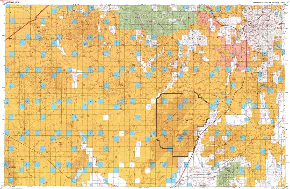
These useful maps show what agency, be it state, BLM, Forest Service, Native lands, or private owner, that manages land and mineral rights in your area of interest. Be sure to find the most current map as rights will change hands over time. You can find these maps on the USGS website. This is the first step of the process and we will narrow it down from here.
Check for Active Claims on the BLM LR2000
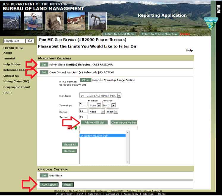
This will show you if there are any existing federal mining claims in your area of interest. These records will not give you a very specific location, but they will give you the quarter section(s) in which the claims are located. You can find a useful guide to using the BLM LR2000 here. Keep in mind that just because a claim isn’t showing up in the LR 2000 doesn’t mean that there haven’t been claims staked in the area that are not recorded in the system yet.
Check Land Status Records on Master Title Plats
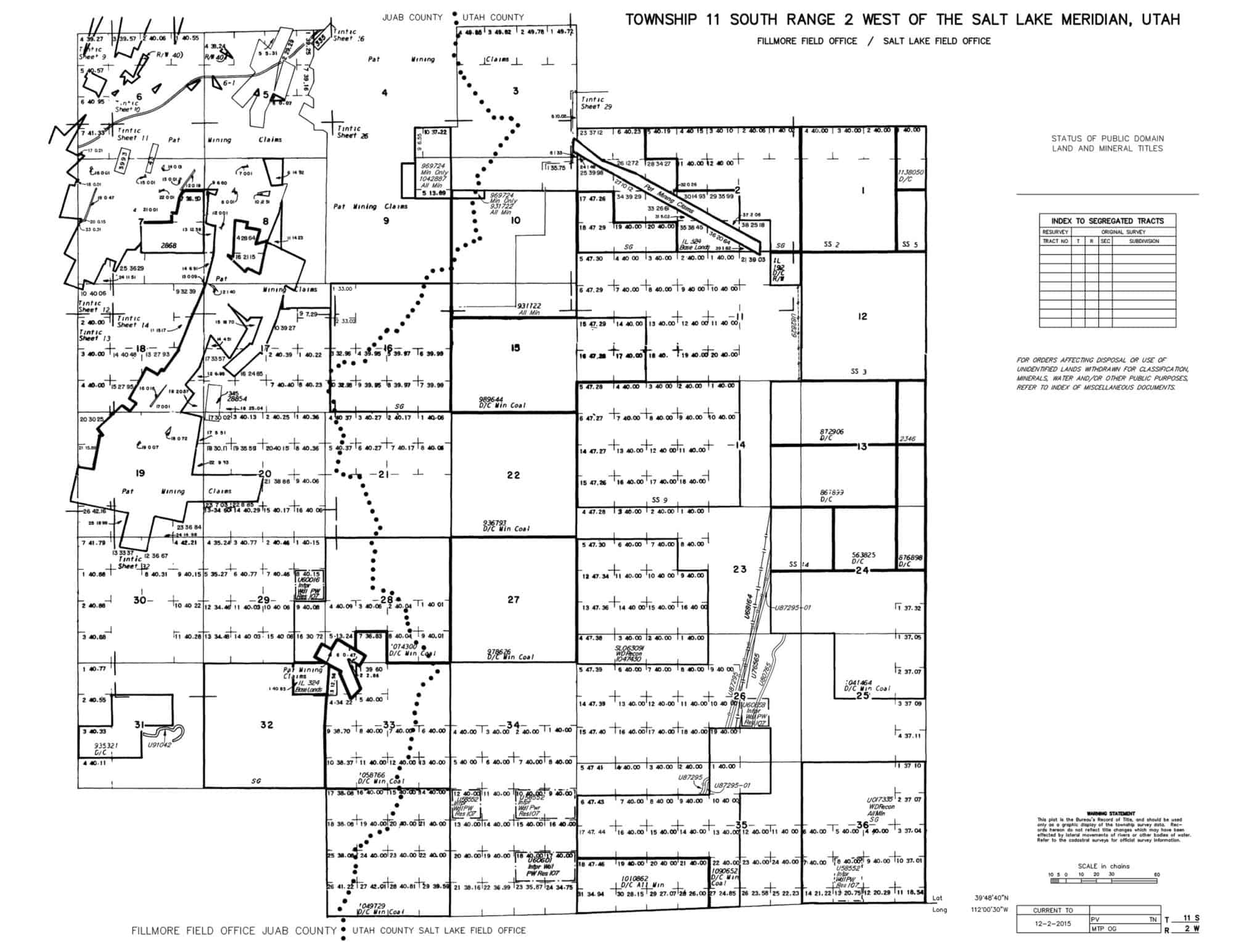
These land status records will advise you of any mineral withdrawals, rights transfers, and other decisions that may effect the mineral rights in your area of interest. You can find the land status records for most Western Status here. The land records for Nevada are available here. These records will show you the detailed boundaries for patented mining claims as well. Be sure to check the index pages for details on record changes. Keep a close eye out for Wilderness Areas and other acts that have removed lands from mineral entry.
Check The County Recorder’s Records
This step is an important one and can vary significantly from county to county. This process is critical because mining claims have to be recorded with the county before they are recorded with the BLM. A claim locator can record a claim with the county months before the claim is recorded with the BLM. This creates a significant gap between when claims have been located on the ground and are entered in the BLM LR2000 database. Checking the county records will give you the best idea of what claims have been recorded recently in the area you are interested in prospecting. The county will always have recorded copies of original and amended notices of location. Some counties such as White Pine County in Nevada maintain very strict requirements for recording mining claims. Although they do not post their records online, they do keep detailed plat maps of claim locations. Other counties only record mining claim notices of location and do not require maps to be filed. Some counties, such as Mohave County, Arizona and Tooele County, Utah have their records posted online and can be searched for a small fee. Other counties have records posted online that can be accessed for free. A simple phone call to the county recorders office in your area of interest will tell you what methods they have available for checking the records.
Check for Monuments and Corners on the Ground
In most states, mine claims have to be filed with the county recorder within 30 days of posting a location monument. This leaves a month-long gap where claims can still be valid and have not yet been recorded with the county. This is why the final step in determining if federal land is open for prospecting is checking for monuments and corners on the ground. Any location monument you find will, by law, contain a notice of location. This notice will tell you the location date of the claim, the locators information, and will have a description of the claim location that should be clear enough for you to understand and interpret.
If you have followed all of these steps and the land is unclaimed and open for mineral entry…
Congratulations on Finding Federal Land Open for Prospecting!
The Western United States is full of federal land open for prospecting. Burgex Inc. has experience researching this process from start to finish and has successfully helped it’s clients locate and stake over 100,000 acres of placer and lode mining claims. If you have additional questions about this content, or would like to hire us to locate and stake your claims or provide consulting, contact us today for a free estimate.