As part of our ongoing efforts to improve our mineral market analysis, mining consulting, and exploration services, the Geographic Information System (GIS) team at Burgex Mining Consultants has been busy developing a comprehensive interactive geospatial model of construction aggregate supply and demand in the Southeastern United States. Likewise, Burgex has built a team of experts with a demonstrated knowledge of various visualization and analytic software. This software ranges from various CAD design software and GIS software with the use of proprietary datasets and data tables to draw from. Similarly, Burgex’s experts are continually refining, enhancing, and taking on new ways to deliver analytic product data to clients, giving more “bang for the buck” and the ability to quickly gain needed project clarity.
The new model built by Burgex’s GIS team analyzes a range of economic, regulatory, environmental, and geological factors. These factors grade potential pit or quarry locations using a grading formula that has been developed by Burgex. It’s been tested on over a hundred greenfield sites throughout the US.
Aggregate Production Map Download
Map Layers
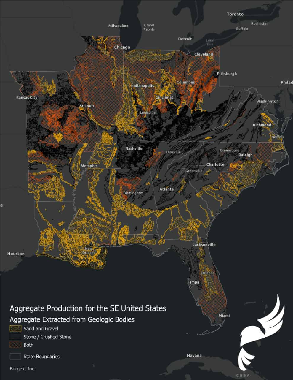
The Aggregate Producing Geologic Bodies Map serves as one of several different layers developed by Burgex Mining Consultants. In addition, this map is analyzed as part of the market analysis and greenfield site grading process. This map layer developed by linking existing construction aggregate producers and their estimated annual production with underlying mapped geologic bodies. These units have been classified as producing sand and gravel, crushed stone, or both. When this weighting scored along with supply and deficit layers, wetlands, incorporated areas, and other factors, it generates an interactive visual representation of local and regional opportunities for potential greenfield pit or quarry site development. In addition to being useful for greenfield development, this analysis can also be used to identify areas with potential construction aggregate supply deficits. This would signify a solid choice for building a distribution yard.
The general process used to build this map can be summarized as follows:
- Map and georeference the location of all active construction aggregate producers in the Southeastern United States.
- Estimate annual crushed stone, sand, and gravel production at each site using a proprietary formula developed by the Burgex Mineral Market Analysis team.
- Combine geology layers from all the Southeastern United States
- Link producers to underlying geological units and weight classifications by annual production quantities of sand and gravel, crushed stone, or both.
Gaining Accurate Predictions
In addition, with recent developments in GIS analytics, Burgex has models in place. These models better determine population densities within desired market sizes and determine predicted aggregate demand over market regions. Models underwent development to better determine supply distribution from producers for the multiple Regions of the United States. They use various correlation and distance-decay algorithms (such as Voronoi Analysis). With this, they can better understand how suppliers are getting construction aggregate products to demanding hot spots in the market.
We’re Expanding
Our GIS and market analysis team is currently working on implementing the latest population and supply data into the Southeast model. It will soon be expanding throughout the rest of the United States. The potential of this analysis tool is to quickly visualize construction aggregate markets and explore potential site suitability. The team is looking forward to expanding its use into other mineral markets. Burgex also has the ability to provide high detail surface topography maps using UAV data collection and in-depth mine design/layout.
In addition, these tools allow a greater understanding of site-specific conditions. Resource estimates, wetland considerations, material transport, and more stand out as important factors. Similarly, these conditions are addressed and evaluated in the market for that specific site. With the combination of CAD software, GIS software, and the knowledge of our market analysts, Burgex has developed advanced means to calculate actuals and appropriate estimates. Furthermore, these estimates involve usable land acreage, quantities of aggregate material, market suppliers concerning market demand. It also includes financing for quarry installation and development using timeframe estimates and production factors and designing mining plans.
Interested in exploring greenfield sites for construction aggregates? Our team can quickly evaluate the potential economics and other development factors. These factors usually go into greenfield site selection before drilling and testing. Contact us today for more information on how our mineral market analysis tools can be used on your project.