By: Jake Alexander
Introduction
Claims have been staked, fees to the county and the Bureau of Land Management have been paid, and now you and your company are excited to prove up the mineral property. According to U.S. federal law you must “prove” a mineral prospect to have a valid claim. In other countries, such as Australia, exploration must be performed annually to maintain valid claims. In the United States it is in the interest of the claim holder to perform exploration to assist in resource development, to encourage investment, and to provide valuable data to shareholders.
In both placer- and lode-type deposits, sampling the soil is one of the most surefire and affordable exploration techniques at your disposal. Before you contract a team (perhaps you want to do a bit of the exploration yourself!), it is useful to understand the principles, procedures and added value that soil sampling can provide to your mineral exploration project.
The advantages of soil sampling as a generative exploration tool are numerous. Soil sampling is the process by which underlying, weathered rock or transported deposits are tested for mineral values. Prior to sampling the mineral prospect, discuss with a consultant the commodity, geology, and the erosional/geomorphological conditions in the area. A consultant can assist you in defining the scope of your project to focus on key areas and provide appropriate data collection goals to target the underlying bedrock. In the case of placer deposits, specifically with respect to placer gold, a review of existing geological maps or the creation of a preliminary geologic map can aid in targeting the prehistoric channels of ancient streams or rivers.
Advantages and Challenges
The advantages of soil sampling include lower labor cost when compared to trenching or drilling, larger areal coverage on a moderately spread sampling grid compared to targeted whole rock exploration, lower geochemical assay cost per unit depending on target commodity, and the ability to perform this type of work in almost all environments. Challenges to soil sampling that may occur are frozen ground, inclement weather and underdeveloped soils in areas of significant bedrock exposure. The section that follows provides a fundamental understanding of the science behind soil sampling, collection technique, analysis process and a few tips on how to achieve optimal success.
What is Soil?
The Oxford English Dictionary defines soil as “the upper layer of earth in which plants grow, a black or dark brown material typically consisting of a mixture of organic remains, clay and rock particles.” However, that definition does not give justice to the complexity of soils, the differentiation of soils at depth and the changing presence of these depth horizons with respect to project area geology and geography. The formation of soil is a direct result of the processes of erosion and weathering. Exposed bedrock disintegrates to soil through the long-term actions of weathering and erosion. In the case of placer-type deposits, associated with fluvial or alluvial transport, the sediments may have been transported by river, rain, wind, or gravity. Analysis of soil adds tremendous value to an exploration project and understanding the formation, general content and framework of soil horizons will assist you in gaining the data that you need.
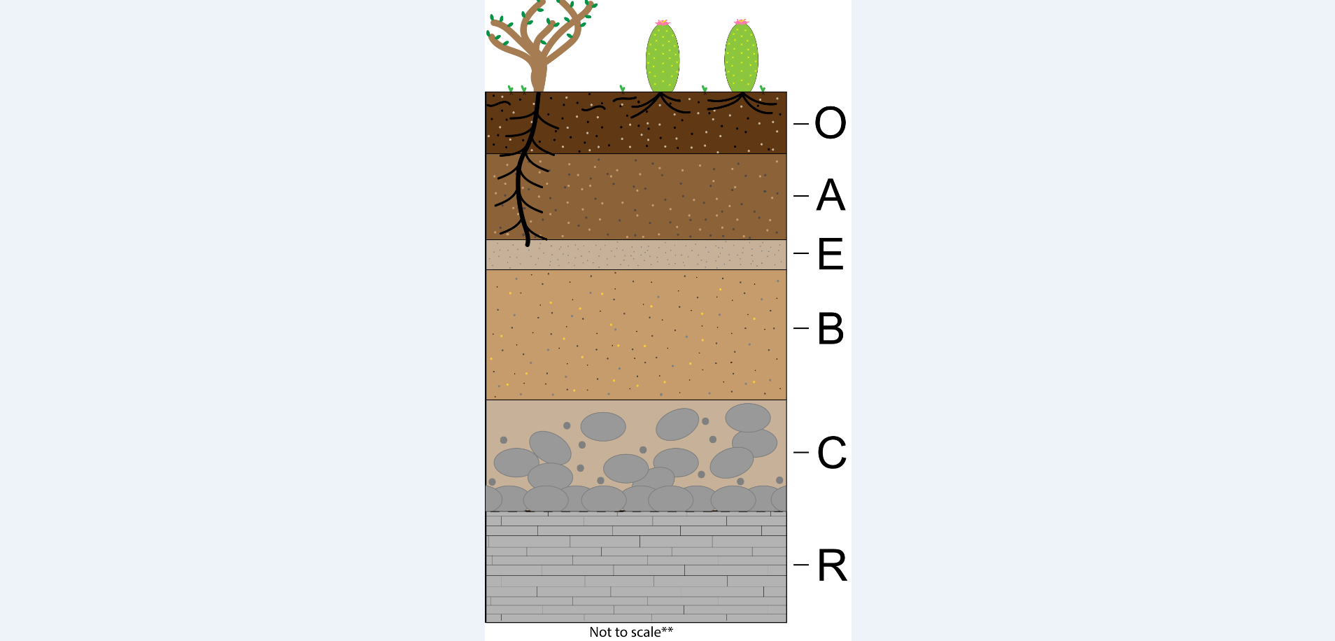
Soil Horizons (please refer to the image for reference below **)
O – Organic Horizon
The organic horizon, or humus, contains significant organic material including vegetation, detritus and roots. This horizon is typically thin (1 to 2 cm) where it is present. In humid, subtropical to tropical environments, the O horizon may be greater than 2 cm and contain significant organic material. This is not a key target for soil sampling, as the biological processes of growth and decay can distort or eliminate mineralogical signatures. In dry, arid environments, the O horizon may not be present at all.
A – Topsoil Horizon
Often rich in organics and minerals the A horizon will have roots that penetrate from above. In the desert this may be as far as the soil development has come, and directly beneath this horizon you may proceed directly to regolith. In many arid environments of the southwestern United States this may be the only soil able to be sampled. In such cases, samples from the A horizon provide the best data for analysis.
E – Eluvial Horizon
This soil horizon can be found in old-growth forests or areas with thick, undisturbed soil. The eluvial horizon is an area of insoluble minerals and quartz grains that range from silt to sand-size particles and that constitute most of the material. This horizon is tan to gray in color due to the mineral leaching of deep, penetrating roots and biological processes. Eluvial soil is not present in underdeveloped soils and is generally nonexistent in arid environments with thin soil generation.
B – Subsoil Horizon
In a well-developed soil the B horizon will deplete in organics and change in color from rich, organic brown or black to lighter brown or tan soil. This horizon is rich in minerals as it is below the level of most biological interaction. Moreover, this horizon is protected from subaerial exposure, such as wind, snow, ice and rain, which may obfuscate the geochemical values. As a rule, the B horizon is the optimal target layer for soil sampling and geochemical detection of mineral content in lower bedrock.
C – Regolith
The regolith, or C horizon, contains weathered rock fragments sourced directly from the bedrock. In this horizon there is almost no life. However, this horizon has not developed further, as in the B horizon, and thus many of the minerals you aim to detect are still tied up in the large rock fragments. This horizon is tricky: the rock fragments may contain the mineral target, but this horizon does not disperse the signal broadly enough to use as a comparative baseline across a large physical area. It is not recommended to sample regolith.
R – Bedrock
Congratulations, you made it to the bottom – or the bottom of the soil profile at least! The R horizon should not be a target of your soil sampling program. If bedrock sampling is what you want you will get better results from outcrop sampling in which you can clearly identify the rock unit or formation.
Sample Collection
How are soil samples collected? In most cases soil samples are collected via the physical process of excavating a location by hand. In extreme cases a soil auger is utilized to penetrate indurated topsoil or hardpan to gain significant depth for your soil sample.
The key target for soil sampling is the B horizon, but the A horizon can substitute if that is the only soil present. Holes are completed using a combination of pickaxe, shovel and trowel. The depth varies with respect to the soil profile development, but generally a 25 to 30 cm depth will reach well into the B horizon. At Burgex Mining Consultants we sieve organic and coarse material (greater than sand-sized particles) prior to collection and analysis. This is a cost-saving measure as laboratories can charge up to $3 per sample for the removal of organics and coarse material. That’s a lot of cash if you collect hundreds of samples. Typically, soil sampling programs follow a predetermined grid with your input; 100-meter spacing will provide a medium density dataset that can cover large areas without compromising the target area. Soil sampling programs will help you define key areas for further exploration, such as trenching and drilling.
In addition to the expert collection of high-quality soil samples for geochemical assay, Burgex provides detailed data on the soil sample collection process. Data collected by our geologists includes depth of sample recovery, lithological outcrop description of underlying bedrock, proximal outcrop and descriptions of large “float” rock in the topsoil, a description of the regolith beneath the soil layers, notable vegetation or presence of human activity, and a physical description of the grain size and macroscopic mineralogy within the sample. We are passionate about providing excellent service and deliverables, and we include a field report that summarizes the overall geology, conditions and detailed notes on the execution of your sampling program.
Summary
An early stage, cost-effective exploration practice, soil sampling will provide high-quality data to help identify mineralogical signals in the subsurface. Preparatory evaluation of your target area from a geological and geographical perspective will improve the quality of your sample grid and the quality of data you seek. Targeting a depth that penetrates the B horizon, where mineral content is of the highest concentration with respect to bedrock, yet below the interference of biological surface processes, will result in the best representation of hidden, valuable minerals. At Burgex Mining Consultants we provide expertise and clarity that help our clients discover and expand the value of their mineral resource project. Contact us today for your mineral exploration programs!